Christchurch Earthquakes
Why do so many earthquakes occur in New Zealand compared to other countries?
One of the reasons many earthquakes occur in New Zealand compared to other countries because we are on the Indo-Australian plate and on the Pacific plate in a transverse boundary. The other is because New Zealand there are a lot of volcanoes and mountain ranges which are caused by plate movements and are where plates collide, (to see how and why these plates collide go to the plate movement page). New Zealand is one of the areas that make up the 'Ring of Fire'. "The Ring of Fire is an area where a large number of earthquakes and also volcanic eruption occur with in the basin of the Pacific Ocean" (explanation by Wikipedia)
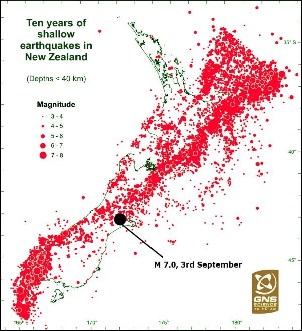
Here is an image showing the number of shallow earthquakes that have occurred over the past 10 years:
One of the reasons many earthquakes occur in New Zealand compared to other countries because we are on the Indo-Australian plate and on the Pacific plate in a transverse boundary. The other is because New Zealand there are a lot of volcanoes and mountain ranges which are caused by plate movements and are where plates collide, (to see how and why these plates collide go to the plate movement page). New Zealand is one of the areas that make up the 'Ring of Fire'. "The Ring of Fire is an area where a large number of earthquakes and also volcanic eruption occur with in the basin of the Pacific Ocean" (explanation by Wikipedia)
Here is an image showing the number of shallow earthquakes that have occurred over the past 10 years:
The other fact why New Zealand has a lot of earthquakes compared to other countries is because we sit on top of the Pacific plate and on the Indo-Australian plate who in our case, have a (something boundary)
What were the plate tectonics involved during the Christchurch earthquakes?
The tectonic plate boundary between the Indo-Australian and Pacific plate passes through the Southern end of the North Island and through the South Island (of New Zealand), were the subduction of the Hikurangi plateau transitions into a continent on continent collision. The Indo-Australian and Pacific plates converge. The collision between these plates is accommodated by a distributed zone of active faults stretching across the bottom of the North Island and across all the South Island. These faults are all capable of causing large magnitude earthquakes such as the Christchurch September 4th 2010 and the February 22nd 2011 earthquake.
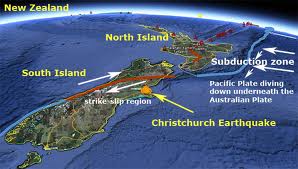
This picture shows the subduction zone mentioned in the explanation above. Christchurch is in/close to a strike strip region, this means that pressure builds up, then is released causing an earthquake. As the waves start leaving the epicenter (the point where the earthquake originated) they cause the earth to shake. This is why Christchurch has many earthquakes and some of high magnitude.
The 4th of September 2010 Earthquake
The 4th of September earthquake was near Christchurch. A magnitude 7.1 occurred at 4:35 a.m. This earthquake was widely felt over the South Island and at the bottom of the North Island but the area that was most affected/had the most damage, was central Canterbury, especially Christchurch. This 7.1 earthquake was the largest earthquake to affect a major urban area since the earthquake in Hawks Bay in 1931. The epicenter of this earthquake was 37 kilometers West of Christchurch, it wasn't very deep, about 10 kilometers below the Canterbury plains. The epicenter was near the town of Darfield, this is why this earthquake's scientific name is the Darfield earthquake but it is more commonly known as the Canterbury earthquake. This earthquake produced the strongest shaking ever recorded in New Zealand.
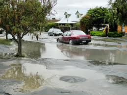
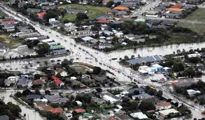
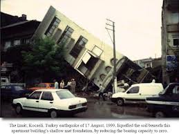
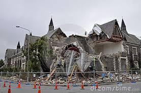
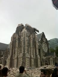
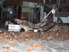
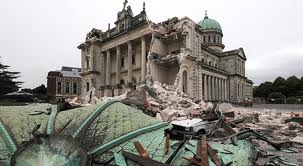
Damage- The fact that the Canterbury earthquake happened in the middle of the night meant that there was practically no one out on the streets, there was no loss of life and few serious injuries. One of the serious injuries though was a chimney that had fallen onto someone. Old buildings (mainly pre-1940s) were the ones that suffered the most with tiles falling off the roofs and down onto the Christchurch footpaths as well as chimneys.Walls crumbled with bricks falling out onto the streets, a number of historic stone churches. A feature that also caused damage in Christchurch was liquefaction, some pipes had even floated up to the surface and the sewer line may have had to be redone. Here are some photos:
Damage- The fact that the Canterbury earthquake happened in the middle of the night meant that there was practically no one out on the streets, there was no loss of life and few serious injuries. One of the serious injuries though was a chimney that had fallen onto someone. Old buildings (mainly pre-1940s) were the ones that suffered the most with tiles falling off the roofs and down onto the Christchurch footpaths as well as chimneys.Walls crumbled with bricks falling out onto the streets, a number of historic stone churches. A feature that also caused damage in Christchurch was liquefaction, some pipes had even floated up to the surface and the sewer line may have had to be redone. Here are some photos:
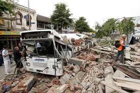
February 22nd 2011 Earthquake
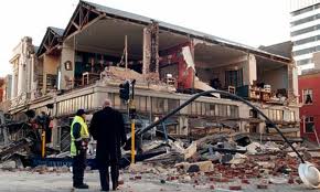
The February 2011 earthquake was considered an aftershock to the 4th of September earthquake because it fit all the criteria needed to be an aftershock (the fact that part of the sequence of earthquakes that closely follow the main shock in time and the other fact that the area which has the earthquake is influenced by the changes in crustal stress level because of the main shock) also, it is not unusual to have a 6 month gap between a 7.1 earthquake and a 6.3 aftershock, aftershocks could continue for even a year. However it is not because the magnitude was smaller that there would be less damage. The main reason why the magnitude 6.3 earthquake in February was able to cause more destruction around Christchurch than the 7.1 earthquake was the fact that the 6.3 earthquake occurred closer to Christchurch than the 7.1 earthquake even though the total energy released in the 6.3 aftershock was only 1/20 of the energy released in the 7.1 earthquake. The fact that it was closer meant that a greater percentage of the total energy released from the 6.3 aftershock hit Christchurch itself.
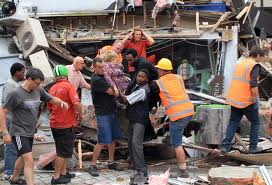
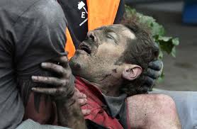
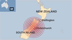
On Tuesday the 22nd of February 2011 at 12:51 p.m. the 6.3 magnitude earthquake hit, killing 185 people and injuring several thousand. The earthquake's epicenter was near Lyttelton, just 10 kilometers south-east of Christchurch's central business area. This earthquake happened on a fault line that was shallow and close to the city, which meant the shaking was particularly destructive and this is why so many people were either injured or died.
Because the earthquake occurred during lunch time, many people were outside on the streets of Christchurch. From the Canterbury Television and Pyne Gould Co-operation buildings more than 10 people died when those 2 building collapsed. 6 people died by bricks crushing the city bus and 11 people died when falling bricks hit them. Rock cliff behind houses collapsed as well and crushed 5 people. Many buildings damaged from the September earthquake were brought down by the earthquake as well.
Liquefaction was a major damaging feature in this earthquake much more than in the Canterbury earthquake. With Eastern sections of the city formerly built over a swamp. The shaking turned the water-saturated layers of sand and silt beneath the earth into a sludge type of substance that squirted up through cracks to the surface followed by water and sewage content from broken pipes. This made houses buckle and crack wreaking many homes. But despite the homes, there were few serious injuries in the liquefied areas.
This earthquake, and the September 4th earthquake has been determined to be on a newly discovered fault line. A newly discovered fault line meaning one that this one has only been discovered. That is because some fault lines are easy to see but the some are underground and can be covered by sediment so without the geophysical searches it wouldn't have been found.